Bromo Tengger Semeru National Park is A Great Natural Art
Bromo Tengger Semeru National Park is a national park located in the east of the island of Java in Indonesia. It is made up of a mountainous region whose highest point is Mount Semeru at 3,676 m, the highest peak in Java.
Bromo-Tengger-Semeru National Park is located on Java Island, Indonesia. What is all this? The park is made up of lakes, rivers, but also the Tengger Caldera which stretches for 10 km, Gunung Semeru, which is the highest peak in Java and the star of the park, Gunung Bromo.
The Tengger Massif and Mount Bromo are part of the park. There are also 4 lakes: Ranu Pani, Ranu Regulo, Ranu Kumbolo and Ranu Darungan, and about fifty rivers.
Endangered species are protected in the park, such as fagaceae, moraceae, sterculiaceae, Casuarina junghuhniana, Anaphalis longifolia and some 200 endemic orchid species.
There are also 137 species of birds, 22 species of mammals and 4 species of protected reptiles. Large animals include the besra hawk (Accipiter virgatus), the green peacock (Pavo muticus), the Java deer (Cervus timorensis), the dhole (Cuon alpinus) and the Java panther (Panthera pardus mela).
In 2015, the park was recognized as a Biosphere Reserve by Unesco.
The Bromo
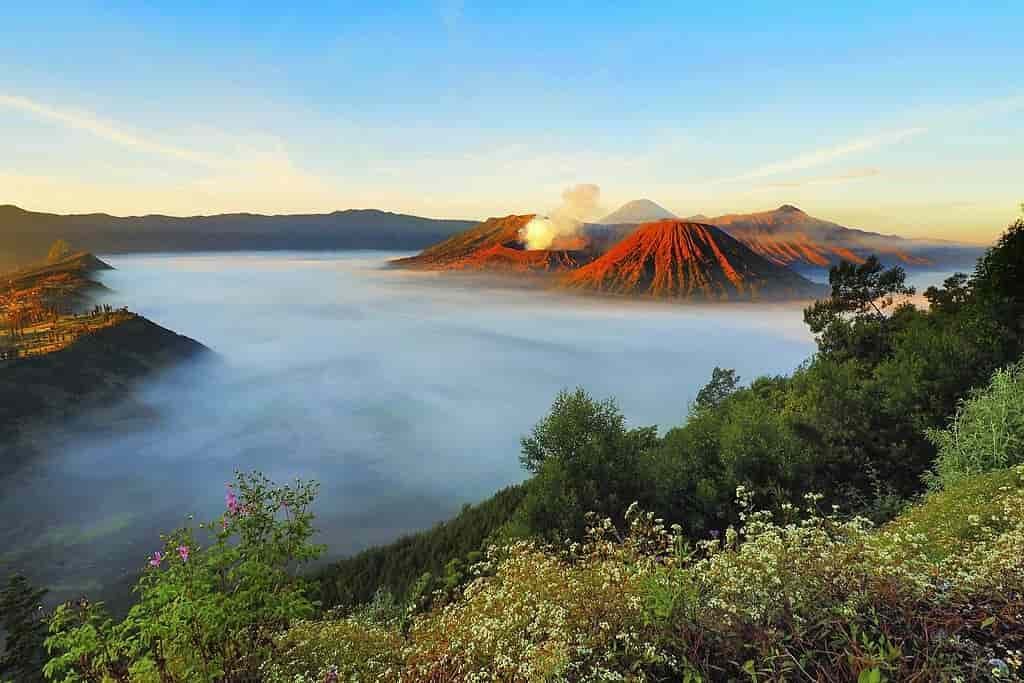
The Bromo volcano (2392m; 800m in diameter, 200m deep) whose name comes from the Hindu god Brahma, is an icon of world tourism (avoid w-e if possible). Its silhouette and easy ascent – 200 steps to reach its smoking crater, after crossing the Sea of Ash – attract tens of thousands of visitors a year.
The most beautiful sunrise embraces the caldera, the Bromo, the neighboring calm Batok and the metronomic eruptive volutes of the Semeru from the Penanjakan (2770 m). Allow 1.5 hours of walking unless you go directly by 4×4.
The Bromo and the Semeru are the subject of Hindu worship served by the Tengger ethnic group, at the Pura Luhur Poten temple and during the Yadnya Kasada ritual.
The Semeru
The Semeru volcano, named in honor of Mount Meru, home of the Hindu gods, is much quieter, except for its projections every 30 minutes…. No wonder since the roof of Java (3676 m) is reserved for experienced hikers.
Its ascent in 3-4 days. remains accessible with a little preparation and the right equipment: good shoes, warm clothes, a powerful torch and a highly recommended guide on the last section, beyond Ranu Pane. At the top, the big reward of a 360° view embracing the Bromo, the caldera and, to the east, the Kawah Ijen and the Balinese Agung and Batur.
The Arjuno
The volcano is made up of two peaks: Arjuno and Welirang, located respectively at the southeast and northwest ends of an alignment of volcanic cones and craters 6k (1,2 miles) in length, which makes it a double volcano. Other alignments of volcanic cones are located on the southern flank of Arjuno along an east-west axis and on the northern flank of Welirang. This volcanic complex covers two older volcanoes: Ringgit to the east and Linting to the south. These 2 peaks are free of vegetation and culminate at 3339 meters above sea level for the Arjuno and 3156 for the Welirang. Solfatares composed of fumaroles and sulfur deposits are located in several places on the Welirang.

Sunrise in the steaming crater of Mount Bromo with stately Mount Semeru imposing in the background. Alec.bernstein, CC BY-SA 4.0, via Wikimedia Commons
Practical information to Bromo Tengger Semeru National Park
Access
Bromo
100 km and 400 km from Surabaya and Yogyakarta respectively. Bus or train to Probolinggo from where minibuses run to Cemoro Lawang (40 km, allow 2 hours). All agencies in the region offer a Bromo package but you don’t have to. Semeru: starting from Bromo, 7 hours of walking to cross the sea of sand and negotiate the steep caldera exit then reach Ranu Pane lake (village, rangers station, tent rental possible). After a night in a losmen (guesthouse), around 7 hours of walking in the forest to the very pretty lake Ranu Kumbolo (alt: 2400 m). Night in a tent and get up… at 1 am for 3 hours of walking in a savannah, 2 hours in the forest then the final section (3 hours) very steep on ash. Alternatively, from Surabaya or Malang via Tumpang to reach Ranupane directly by minibus then 4X4.
Accommodation
Bromo: book in advance or arrive before 3:00 p.m. at Cemoro Lawang otherwise you will not find anything correct, especially the week-end. Semeru: Losmen to Ranu Pane then camping.
When to go?
Bromo: best views during the dry season (Apr-Nov). Yadnya Kasada festival: full moon of the 1st month of the local calendar (between Sept and Dec). Semeru: avoid Dec-March when the ashes turn into dangerous slippery mud.
Culture around Bromo Tengger Semeru National Park
The area in and around the park is inhabited by Tengger. The people of this ethnic group make up significant Hindu communities on the island of Java. It has features that are comparable to that of Bali , but contain more animistic elements. It is believed that the Tengger population can be traced back to descendants of the Majapahit Empire, who moved to the Pulau Maduras mountains before the arrival of Islam in the region.
The Tengger People
The Tengger are about 40,000. They live on the slopes of the Semeru volcano and all around the Tengger caldera, in the region of Probolinggo, Pasuruan, Lumajang dan Malang. The Tengger speak a variant of Javanese (Jawa Tengger) which is actually Ancient Javanese, with no language levels.
The Tengger massif has been considered sacred since the days of the Hindu kingdom of Majapahit in the 15th century. The population remained Hindu there even after the Islamization of Java, although tangible vestiges of this distant time are very few (the remains of a bronze bell have been found on the northern slope of the massif).
According to local belief, the Tenggers are the descendants of a mythical couple: Joko Seger (son of a Brahmin priest) and Roro Anteng (daughter of a king of Majapahit). During the time of the kingdom of Majapahit, in the 14th and 15th centuries, the inhabitants of Tengger had a special status. Indeed, in this region is, south of Bromo, the Semeru volcano, considered as the residence of the gods by the Hindus of Java. The inhabitants of Tengger were therefore considered to be the guardians of the place. During the Islamization of Java, the inhabitants of Tengger remained Hindus to the present day.
The Bromo volcano is the incarnation of the Hindu god Brahma, who is also the god of fire… As such, this volcano is revered and feared by the Tengger Each year, they observe the Kasodo ceremony which consists of making offerings to the crater, as well as other Hindu rituals.
Volcanism
The only inactive volcano in the Tengger volcanic complex, the Batok, is covered in casuarina trees . On Mount Widodaren there is a cave of the same name that is considered sacred by the locals.
The five volcanoes of the ancient caldera are surrounded by a vast area of sand, the so-called Sea of Sand, which in turn is surrounded by a very steep escarpment that forms the walls of the Tengger caldera, which is between 200 and 600 meters high. . Other mountains around the Tengger caldera are Mount Pananjakan (2 770 m) Mount Cemorolawang (2 227 m) Mount Lingker (2 278 m) Mount Pundak Lembu (2 635 m) Mount Jantur (2 705 m) Mount Ider- ider (2 527 m) and mount Mungal (2 480 m). The Pananjakan summit is the most popular place to get a panoramic view of the entire Tengger complex.
In the park there is another volcanic complex, located further south and called the Semeru group or Jambangan group. It is there that Mount Semeru is located , the highest mountain in Java. Other mountains in this area are Mount Lanang (2,313 m), Mount Ayek-ayek (2,819 m), Mount Pangonan Cilik (2,833 m), Mount Keduwung (2,334 m), Mount Jambangan (3,020 m), Mount Gentong (1951 m), Mount Kepolo (3 035 m) and Mount Malang (2 401 m). Semeru Forest has many rivers that flow in ancient lava beds of Mount Semeru. The Semeru group produces many volcanic materials, such as lava, ash and hot clouds, which are scattered in the surrounding areas. The lower part is surrounded by fertile rice fields.
The road leading us from Probolinggo to Cemoro Lawang, a small village serving as a starting point for the visit of Gunung Bromo, was a nice surprise and a great challenge. The many terraced crops on the mountainside at 75 degree angles are unique and quite impressive. This roughly an hour’s drive through a crowded bemo leaves us with a sore legs and a great vibe of what lies ahead.
How to get to Bromo in a tight budget?
From Probolinggo take any yellow bemo and ask the driver to drop you off at Bayuangga bus station (5000Rp). Probolinggo gets a bad rap thanks to crooks. The bemo will therefore try to either leave you at an agency or make a short stop to pick up “a friend” who will ask you where you are going to “help you”. Be firm with the driver and demand to be dropped off at Bayuangga station and have fun answering “bus station” and “traveling” loop to the friend, who asks you “where you going”.
To the right of the terminal you will see green or blue minibuses ready to go when full. The “characters” in charge of filling the minibus are highly disagreeable, so ask for the price ignoring their haughty attitude (IDR 45,000). Warning! don’t pay anyone upfront, you’ll pay on the road. Wait an hour or two outside the bemo, passengers will arrive, that’s for sure! You will be told that the bemo will not fill up and if you still want to go to Bromo, you will have to pay for the empty places and leave right away. Tell them nicely that you are going to wait and quell the desire to hit those mierda crooks. Otherwise, if you have money and little time.
If you don’t have a hotel say you are going close to Cemara Indah, otherwise they will drop you far, far, far away at their dear friend’s expensive hotel.
Sources: PinterPandai, Villa Carissa Seminyak SurabayaApartments, ResearchGate, Unesco
Photo credit: Aprisonsan / Wikimedia Commons (CC BY-SA 4.0)
Main photo description: The Beauty of Mount Bromo, Mount Batok and Mount Semeru in a warm sunrise where the fog still covered the sea of sand of Bromo in the silent morning. The volcanoes belong to the Bromo Tengger Semeru National Park.