Astronomical coordinate systems
In astronomy, a celestial coordinate system or astronomical coordinate systems is a coordinate system for determining a position in the sky, usually expressed in decimal or pseudo-sexagesimal notation (the base unit of right ascension, however, being sidereal time, equivalent at 15°).
There are several systems, using a coordinate grid projected onto the celestial sphere, analogous to the geographic coordinate systems used on the Earth’s surface. The celestial coordinate systems differ only in the choice of the reference plane, which divides the sky into two hemispheres along a great circle (the reference plane of the geographic coordinate system is the earth’s equator).
Each system is named after its reference plane:
Here are some additional details about each of these astronomical coordinate systems:
- Horizontal Coordinate System:
- This system is like a compass for the sky. It helps us locate objects in the sky from our specific location on Earth.
- It uses two coordinates: azimuth (like a compass direction) and altitude (how high above the horizon an object is).
- It’s great for stargazers since it tells them exactly where to look.
- Equatorial Coordinate System:
- Imagine lines that wrap around the Earth like a grid. This system uses those lines, which are projections of the Earth’s equator and poles, to locate stars and celestial objects.
- It’s like a global address for the universe.
- Ecliptic Coordinate System:
- Picture a line that shows the path the sun follows through the sky over the course of a year. This system uses that line as a reference.
- It helps us find objects that are part of our solar system, like planets.
- Galactic Coordinate System:
- This system is like a GPS for our galaxy, the Milky Way. It uses the Milky Way’s center and its equator as points of reference.
- It’s useful for studying objects within our galaxy, like star clusters and gas clouds.
- Supergalactic Coordinate System:
- This is a super-big map for really, really far-away things in space. It covers distances up to a hundred million light-years.
- It uses a reference point called the supergalactic plane, which is like a giant flat surface that helps us figure out where galaxies and clusters of galaxies are.
These coordinate systems are like different sets of directions that scientists use to explore and study the universe. They’re like tools that help us navigate through space and understand the vastness of it all!
Table lists the common coordinate systems in use by the astronomical community
| Coordinate system | Center point (origin) | Fundamental plane (0° latitude) | Poles | Coordinates | Primary direction (0° longitude) | |
|---|---|---|---|---|---|---|
| Latitude | Longitude | |||||
| Horizontal (also called alt–az or el-az) | Observer | Horizon | Zenith, nadir | Altitude (a) or elevation | Azimuth (A) | North or south point of horizon |
| Equatorial | Center of the Earth (geocentric), or Sun (heliocentric) | Celestial equator | Celestial poles | Declination (δ) | Right ascension (α) or hour angle (h) | March equinox |
| Ecliptic | Ecliptic | Ecliptic poles | Ecliptic latitude (β) | Ecliptic longitude (λ) | ||
| Galactic | Center of the Sun | Galactic plane | Galactic poles | Galactic latitude (b) | Galactic longitude (l) | Galactic Center |
| Supergalactic | Supergalactic plane | Supergalactic poles | Supergalactic latitude (SGB) | Supergalactic longitude (SGL) | Intersection of supergalactic plane and galactic plane | |
Functions
A celestial coordinate system has the function of determining a position in the sky. There are several systems, using a coordinate grid projected onto the celestial sphere, analogous to the geographic coordinate systems used on the Earth’s surface.
The celestial coordinate systems differ only in the choice of reference plane, which divides the sky into two hemispheres along a great circle (the reference plane of the geographic coordinate system is the Earth’s equator). Each system is named after its reference plane.
The systems of astronomical coordinate
Horizontal coordinate system
The horizontal coordinate system, also called local system or alt-azimuth coordinate system, is a system of celestial coordinates used in astronomy by an observer on the ground. The system, centered on the observer, separates the sky into two hemispheres: one located above the observer and the other located below, hidden by the ground. The circle separating the two hemispheres, called the celestial horizon, locates the horizontal plane. The altitude (or elevation, “h”) and the azimuth (A), which constitute the two main coordinates of this system, are defined from this plane.
Altitude is the angle between the object and the observer’s local horizon. For visible objects, this angle is between 0° (horizon) and 90° (zenith).
Azimuth is the angle of the object around the horizon. It is a circle divided into 360° drawn on the horizontal plane from north to east (exceptions to this convention exist).
This coordinate system has the advantage of being simple and local. It is easy to establish at a given place from the moment the observer knows where one of the cardinal points is. This is the reason why it is particularly used by ground-based telescopes with azimuthal mounting, that is to say most of the most recent telescopes.

Horizontal coordinates use a celestial sphere centered on the observer. Azimuth is measured eastward from the north point (sometimes from the south point) of the horizon; altitude is the angle above the horizon. TWCarlson, CC BY-SA 3.0, via Wikimedia Commons
Nearest Galaxy and the distance from Milky Way (our galaxy)?
Equatorial coordinate system
The equatorial coordinate system is a celestial coordinate system whose values are independent of the position of the observer. This is also true for ecliptic and galactic coordinate systems. This system uses the projection of the Earth’s equator on the celestial sphere as a reference plane. This projection is called the celestial equator. It divides the sky into two hemispheres, each having as its axis of reference the projection of a terrestrial pole, perpendicular to the celestial equator. From these divisions, the system makes it possible to establish two angular coordinates: right ascension and declination.
Read also: Astrophysics | Definition and Explanations
Right ascension (α) is the angle measured on the celestial equator from an axis pointing to a reference point, the vernal point, corresponding to the intersection between the celestial equator and the ecliptic. From this axis, the angle is measured towards the East and has 24 main divisions of 15° each, called “hours”. Each hour is divided into minutes and seconds. This division of the angle into hours, minutes and seconds makes it easy to determine how long (in sidereal time) it will take for a star to reach a certain point in the sky.
The declination (δ) is the angle measured perpendicularly between the celestial equator and the observed celestial object. It is measured in degrees, positive for objects in the northern hemisphere and negative for those in the southern hemisphere. The declination thus varies from -90° (south pole) to +90° (north pole) passing through 0° at the celestial equator. Right ascension and declination are the astronomical equivalents of longitude and latitude.

Geocentric equatorial coordinates. The origin is the centre of the Earth. The fundamental plane is the plane of the Earth’s equator. The primary direction (the x axis) is the vernal equinox. A right-handed convention specifies a y axis 90° to the east in the fundamental plane; the z axis is the north polar axis. The reference frame does not rotate with the Earth, rather, the Earth rotates around the z axis. Tfr000 (talk) 19:24, 23 April 2012 (UTC), CC BY-SA 3.0, via Wikimedia Commons
Ecliptic coordinate system
The ecliptic coordinate system is a coordinate system suitable for celestial objects: it uses the ecliptic plane (plane of the Earth’s orbit around the Sun) as a reference plane. This plane makes an angle of approximately 23° with the Earth’s equatorial plane, due to the tilt of the Earth’s axis of rotation. This frame is a two-dimensional spherical system.
The ecliptic longitude (λ) is the angle between the vernal point (the same as for the equatorial coordinate system), the center of the coordinate system (the sun) and the projection of the object on this plane. This angle is measured in degrees.
The ecliptic latitude (β) represents the angle between the plane of the ecliptic, the center of the frame (the sun) and the object.
This system can be centered on the Earth, the Sun or any other body. It is especially useful for objects located in the solar system.
The obliquity, or inclination of Earth’s equator against the ecliptic, amounts eps[ilon] = 23deg 26′ 21.448″ (2000.0) and changes very slightly with time, due to gravitational perturbations of Earth’s motion. Knowing this quantity, the transformation formulae from equatorial to ecliptical coordinates are quite simply given (mathematically, by a rotation around the “X” axis pointing to the vernal equinox by angle eps):
cos be * cos le = cos Dec * cos RA
cos be * sin le = cos Dec * sin RA * cos eps + sin Dec * sin eps
sin be = – cos Dec * sin RA * sin eps + sin Dec * cos eps
and the reverse transformation: cos Dec * cos RA = cos be * cos le
cos Dec * sin RA = cos be * sin le * cos eps – sin be * sin eps
sin Dec = cos be * sin le * sin eps + sin be * cos eps
Ecliptical coordinates are most frequently used for solar system calculations such as: planetary and cometary orbits and appearances.
For this purpose, two ecliptical systems are used:
- The heliocentric coordinate system with the Sun in its center.
- The geocentric one with the Earth in its origin, which can be transferred into each other by a coordinate translation.
.svg)
Ecliptic coordinate system (celestial) Joshua Cesa, CC BY 3.0, via Wikimedia Commons
Galactic coordinate system
Galactic coordinates are suitable for objects located in our galaxy and not located in the near vicinity of the Sun. Galactic coordinates are a location made using a latitude and longitude defined so that the galactic plane corresponds to the equator, and the origin of the longitudes corresponds to the galactic center. The galactic coordinate system is a celestial coordinate system that takes into account the rotation of the Galaxy on itself. We are also talking here about galactic longitude and latitude. The reference plane of this system is the plane of the Galaxy centered on the galactic center. The galactic north pole has been defined by convention in the equatorial reference frame by a right ascension of 12 h 51 min 26.282 s and a declination of 27°07′42.01″. In this plane, the reference direction of the measurement is the direction of the center of the Galaxy.
Galactic longitude (l) is the angle between this direction of reference and the projection of the object on the plane of the galaxy. The galactic longitude is 0° in the direction of the center of the Galaxy.
Galactic latitude (b) is the measure of the angle between the reference plane and the object with the Sun at the center. It measures in degrees the height of this object from 0° in the reference plane to 90° at the galactic north pole.

Ilustration of the galactic coordinates use the Sun as the origin. Galactic longitude (ℓ) is measured with primary direction from the Sun to the center of the galaxy in the galactic plane, while the galactic latitude (b) measures the angle of the object above the galactic plane. Brews ohare, CC BY-SA 3.0, via Wikimedia Commons
Supergalactic coordinate system
The supergalactic coordinate system is like a giant map for really, really far-away things in space. It helps scientists figure out where things are that are millions of light-years away.
This map is based on something called the supergalactic plane, which scientists first noticed in the 1700s. They were sure about it only in the 1970s. This plane kind of shows us where the Virgo Supercluster is, which is a massive group of galaxies.
Compared to our Milky Way, this supergalactic plane sits at an angle of about 84.5 degrees, almost like a big T-shape. It passes through different star groups like Cassiopeia, the Giraffe, the Big Dipper, and others. It’s like drawing lines in the sky to help scientists study really far-off places.
Understanding these big structures helps scientists learn more about the huge universe we live in.

Galaxies and galaxy clusters plotted in the supergalactic plane < 50 million lightyears distance. RobbertMoolhuijsen, CC BY-SA 4.0, via Wikimedia Commons
Where exactly the posisition of astronomical coordinate systems?
Astronomical coordinate systems are not physical objects or locations in space. Instead, they are mathematical frameworks or systems that astronomers use to precisely describe the positions of celestial objects in the sky. These systems are like specialized maps or grids used to locate stars, planets, galaxies, and other celestial bodies.
The positions described using these coordinate systems are relative to certain reference points or planes, which are defined within these mathematical systems.
For example:
- The Equatorial Coordinate System uses the Earth’s equator and poles as reference points.
- The Ecliptic Coordinate System uses the path of the Sun across the sky (the ecliptic) as a reference.
- The Galactic Coordinate System uses the center and equator of our Milky Way galaxy.
- The Supergalactic Coordinate System uses a reference plane related to the supergalactic structure of the universe.
These systems provide astronomers with a standardized way to communicate and precisely locate celestial objects, regardless of where they are observed from on Earth. They are essential tools for conducting observations, performing calculations, and sharing information in the field of astronomy.
Ptolemy (85 – 165), Mathematician, Geographer, Astronomer and Astrologer
Sources: PinterPandai, University of Rochester, Sky & Telescope
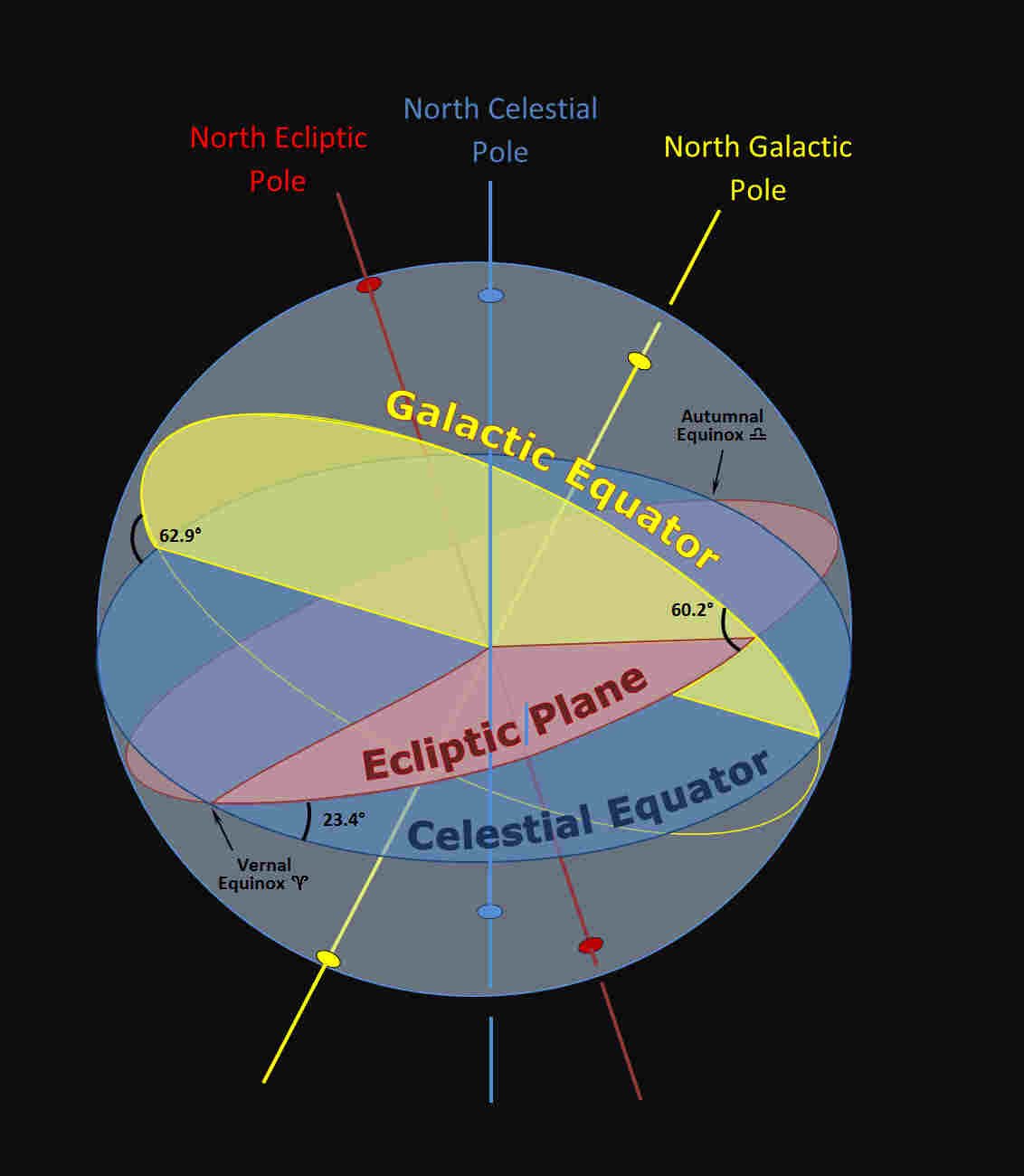
Photo credit (main picture): Jim slater307 (CC BY-SA 4.0) via equinox
Main photo description: Celestial Equator (blue), Ecliptic Plane (red), and Galactic Equator (yellow) projected on the Celestial Sphere, showing the inclinations of their respective poles and equators.